Research interests
I research the interaction between anthropogenic subsurface activities and seismic and environmental hazards. Injection and production of fluids into/from geological formations is essential to many energy and environmental problems. For example, oil and gas production, hydraulic fracturing, wastewater disposal and enhanced geothermal energy production are important activities associated with energy production activities. Similarly, large-scale CO2 storage in geological formations is an important climate change mitigation technology. These activities, however, can often induce earthquakes that, in some cases, can pose a risk to infrastructure. Therefore, understanding the physical mechanisms that can lead to these earthquake occurrences is an important first step towards mitigation strategies.
Below are examples of projects that illustrate my research activities on the topic of anthropogenic activities and earthquake hazards.
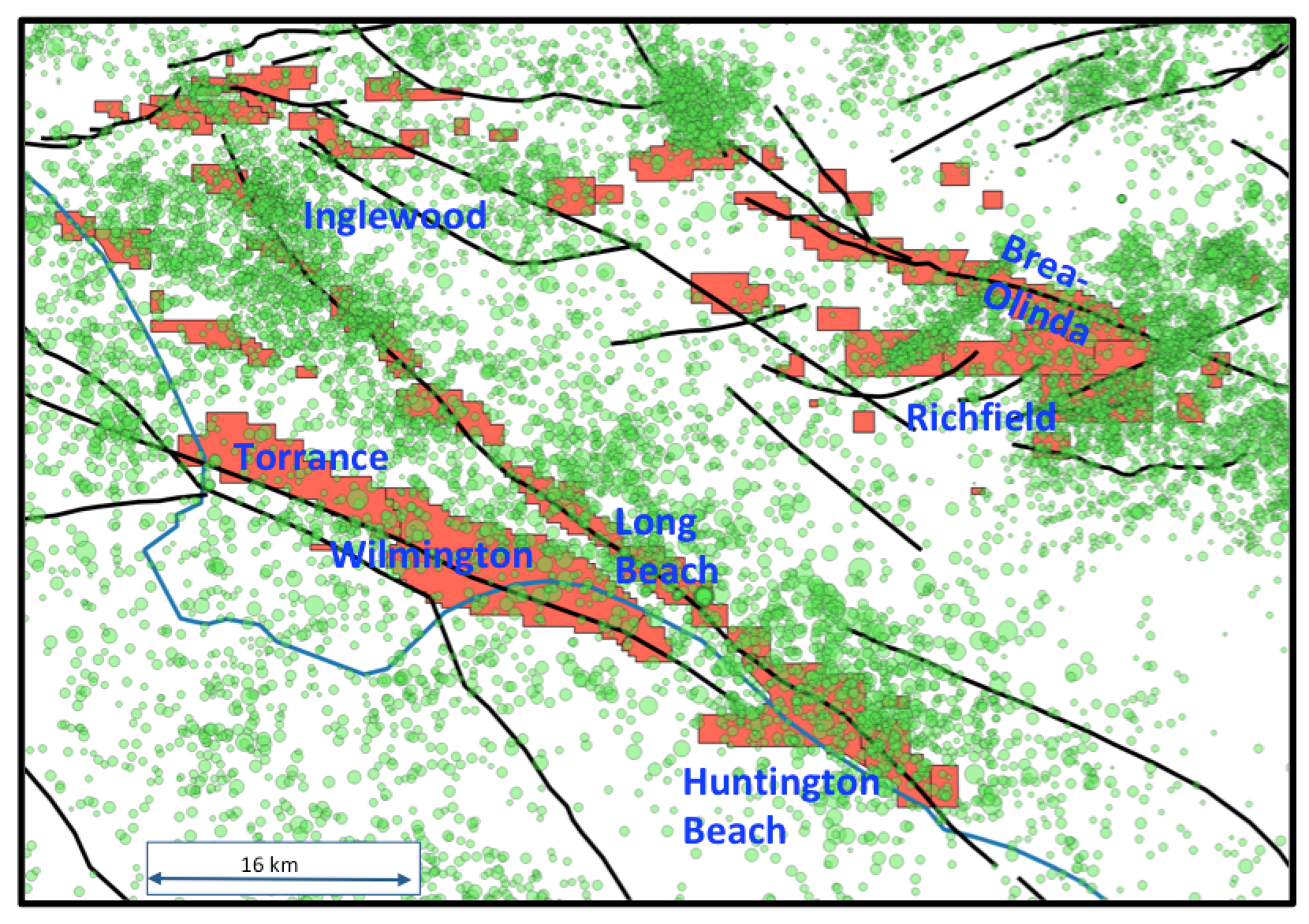
Earthquake hazards and oil production in the Los Angeles Basin
The Los Angeles Basin has a long history of oil and gas production, with some oil fields producing since the beginning of the 20th century. Similarly, nearly a century of earthquake monitoring in this area have indicate an extensive occurrence of small to moderate earthquakes in the LA basin. The goal of this project is to investigate the impact of long-term oil and gas production in the LA basin on seismic hazards, specially near the major fault systems underneath the oil fields which are capable of generating large earthquakes.
 |
|---|
| Earthquake locations (green circles) and outline of oil fields (red polygons) in the Los Angeles Basin. The black-solid lines are the locations of major structural faults in this area. |
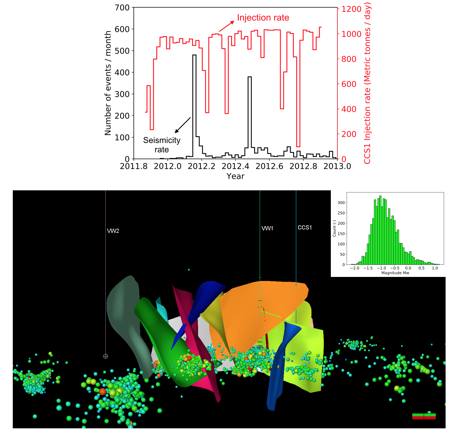
Mechanism associated with microseismicity occurrence during CO2 injection
Large-scale CO2 storage in geological formations is an essential climate change mitigation technology. However, it is well known that fluid injection in subsurface is capable of triggering earthquakes — in some cases of moderate magnitudes. Therefore, it is important to understand the mechanisms that result in earthquake occurrence associated with injection activities, so as to design efficient mitigation strategies. This project seeks to investigate the mechanisms that resulted in extensive microseismicity occurrence during injection of 1 million tons of CO2 in Decatur, Illinois, USA. The project outcome is a better understanding of the hydraulic and geomechanical conditions that can lead to induced seismicity associated with CO2 storage in geological formations.
 |
|---|
| Top: Temporal variation of CO2 injection rate and seismicity rate. Bottom: 3D view of earthquake locations (colored circles), fault planes (colored planes). The inset shows earthquake magnitude distribution. |
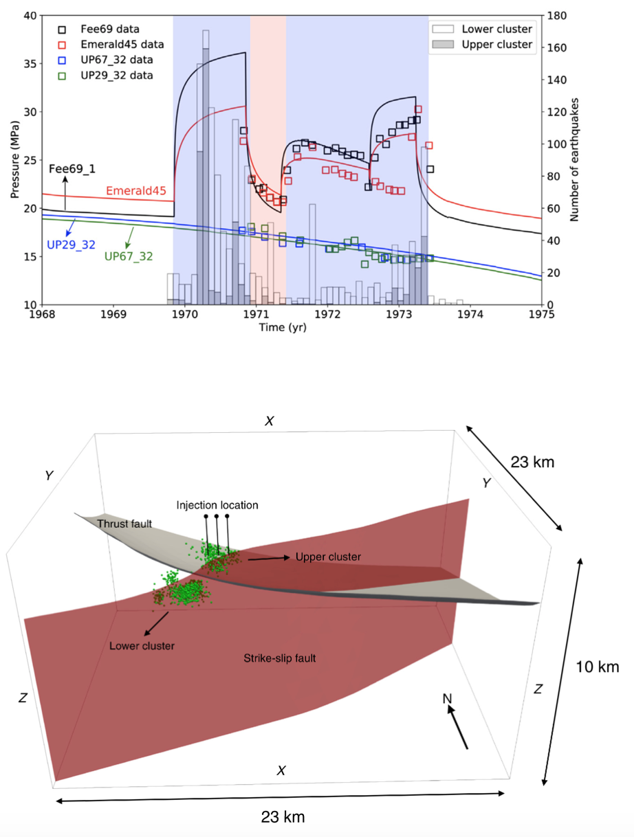
Revisiting the classical experiment on earthquake control at Rangely, Colorado, using coupled multiphase flow and geomechanics
This project revisited the classical field experiment on earthquake control conducted at the Rangely oil field, CO, in 1970. In this experiment, multiple cycles of water injection and water withdrawal were performed, with the associated microseismicity monitored. The original experiment was seminal to show qualitatively that fluid injection in subsurface can induce earthquakes. Using coupled multiphase flow and geomechanics, this project provided a mechanistic quantitative explanation for why and how water injection resulted in earthquake occurrence.
Additional information about this work can be found in the following references:
-
Revisiting the classical experiment in earthquake control at the Rangely oil field, Colorado, 1970, using a coupled flow and geomechanical Model. Josimar A. Silva, Hannah Byrne, Andreas Plesch, John H. Shaw, Ruben Juanes; Bulletin of the Seismological Society of America; 2021; https://doi.org/10.1785/0120210020
-
The groundbreaking experiment in earthquake control at Rangely, Colorado, revisited. Hannah Byrne, Josimar A. Silva, Andreas Plesch, John H. Shaw, Ruben Juanes; Geophysical Research Letters, 47, e2020GL088257; 2020; https://doi.org/10.1029/2020GL088257
 |
|---|
| Top: Temporal variation of reservoir pressure (squares are data, black-solid lines are model results) and earthquake frequency (histogram). The blue- and red-shaded area indicate periods of water injection and withdrawal, respectively. Bottom: location of microseismicity occurrence (green circles) with respect to the injection location. The red-vertical plane is a major strike-slip fault that sourced the earthquakes in this area. The gray sub-horizontal plane is a blind-thrust fault that is seismically inactive. |
##